Results
Cluster Analyses
Having assessed the general variability in the data, both chemistry and landscape, cluster analyses were performed on the chemistry data. Cluster analyses are a statistical technique that searches data for groupings based on similarity. While several different methods of cluster analyses can be applied, in this case the Ward’s algorithm, which searches for those two groups that will add the smallest increment to the within-group variation. To numerate the distance between clusters identified with Ward’s algorithm, the method of Euclidean distance was used.
Cluster analyses were used to identify main groupings of chemistry to maximize internal similarity and prevent the noise caused by extremes in chemistry that might reduce the effectiveness and accuracy of further analyses. As performing a cluster analysis on the individual ponds would create a dendogram to large and crowded to be properly descriptive, analyses were performed on the median chemistry found in each ecodistrict sampled. Median and not mean chemistry was used, as Ward’s algorithm is highly sensitive to outliers.
Significant splits in ecodistrict median chemistry were validated based on employing cut levels of 40% and having the cluster created by this cut level supported by ‘Approximately Unbiased P-values’ equal to or greater than 75.
Geochemistry cluster analysis
The first cluster analysis was performed based on the median geochemistry (ion concentration, pH and electrical conductivity) of each Canadian ecodistrict sampled. It was assumed that extreme highs in geochemistry would be identified in the Boreal Cordillera and at the transition zone into the Boreal Shield. Extreme lows were expected at the northernmost ponds located in permafrost, while the remaining ponds situated across the Boreal and Taiga Plains would possess intermediate chemistry signatures in comparison with the two groups.
Setting a cut-level at 33%, a total of four cluster were identified across the sampled ecodistricts in the Western Boreal Forest. These cluster were identified as having overall decreasing concentrations in geochemistry moving from cluster a to D, respectively (Fig.5). Although these results showed one more cluster than was expected, the general outcome was as predicted (Fig.6): extreme highs in geochemistry were found in the Boreal Cordillera and at the transition zone into the Boreal Shield (cluster A & B). Extreme lows were found at the northernmost ponds located in permafrost, but also in ponds located atop granite in the Boreal Cordillera. As expected,the remaining ponds situated across the Boreal and Taiga Plains possessed an intermediate chemistry signature in comparison. The main cause for this divergence in geochemistry was further investigated via the Gibbs models.
Setting a cut-level at 33%, a total of four cluster were identified across the sampled ecodistricts in the Western Boreal Forest. These cluster were identified as having overall decreasing concentrations in geochemistry moving from cluster a to D, respectively (Fig.5). Although these results showed one more cluster than was expected, the general outcome was as predicted (Fig.6): extreme highs in geochemistry were found in the Boreal Cordillera and at the transition zone into the Boreal Shield (cluster A & B). Extreme lows were found at the northernmost ponds located in permafrost, but also in ponds located atop granite in the Boreal Cordillera. As expected,the remaining ponds situated across the Boreal and Taiga Plains possessed an intermediate chemistry signature in comparison. The main cause for this divergence in geochemistry was further investigated via the Gibbs models.
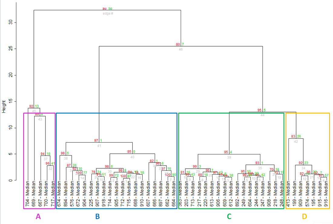
Fig.5: Cluster analysis of the median ecodistrict geochemistry. Four main groups (illustrated by boxes) were identified by a 40% cutlevel and supported by a Approximately Unbiased
P-value of 75% or higher.
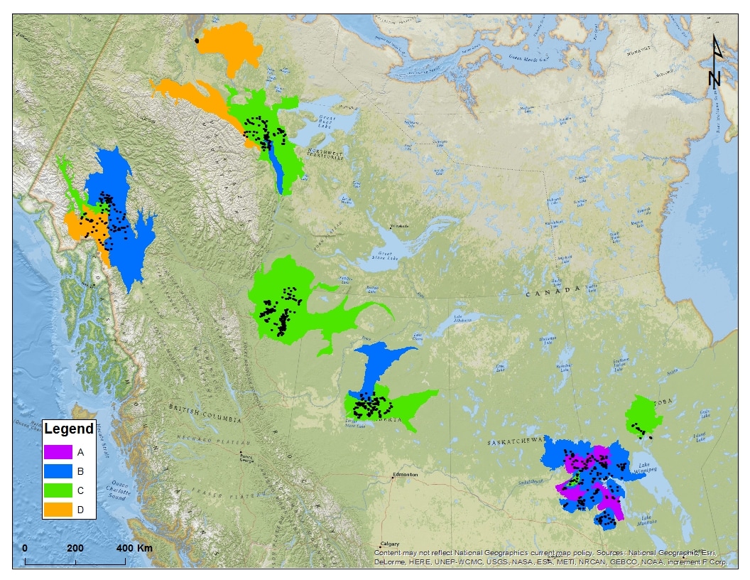
Fig.6: Ecodistrict grouping identified by the geochemistry cluster analysis.
Nutrient cluster analysis
As with geochemistry, a cluster analysis was performed on pond nutrient levels (Fig.7), looking at the variability of TDN, TDP and DOC specifically. It was expected that this analysis on nutrient variability would show a first split between ponds situated in the Boreal Cordillera, due to an absence of any major peatlands, followed by a secondary split between ponds situated in the center of the Taiga and Boreal Plains and those situated at the edge of the Western Boreal Forest.
This analysis identified only two clusters, as an additional split in the second cluster (B) was not supported by the Approximately Unbiased P-values (p-values were found to be 57 and 50 for the two clusters). The single split supported by the CA divides the ecodistricts between those sampled in the Boreal Cordillera and Boreal Shield and those sampled in the Boreal and Taiga Plain (Fig.8). The deviataion between the two clusters was caused by a large increase in concentration of all nutrients, moving from cluster A to B.
This analysis identified only two clusters, as an additional split in the second cluster (B) was not supported by the Approximately Unbiased P-values (p-values were found to be 57 and 50 for the two clusters). The single split supported by the CA divides the ecodistricts between those sampled in the Boreal Cordillera and Boreal Shield and those sampled in the Boreal and Taiga Plain (Fig.8). The deviataion between the two clusters was caused by a large increase in concentration of all nutrients, moving from cluster A to B.
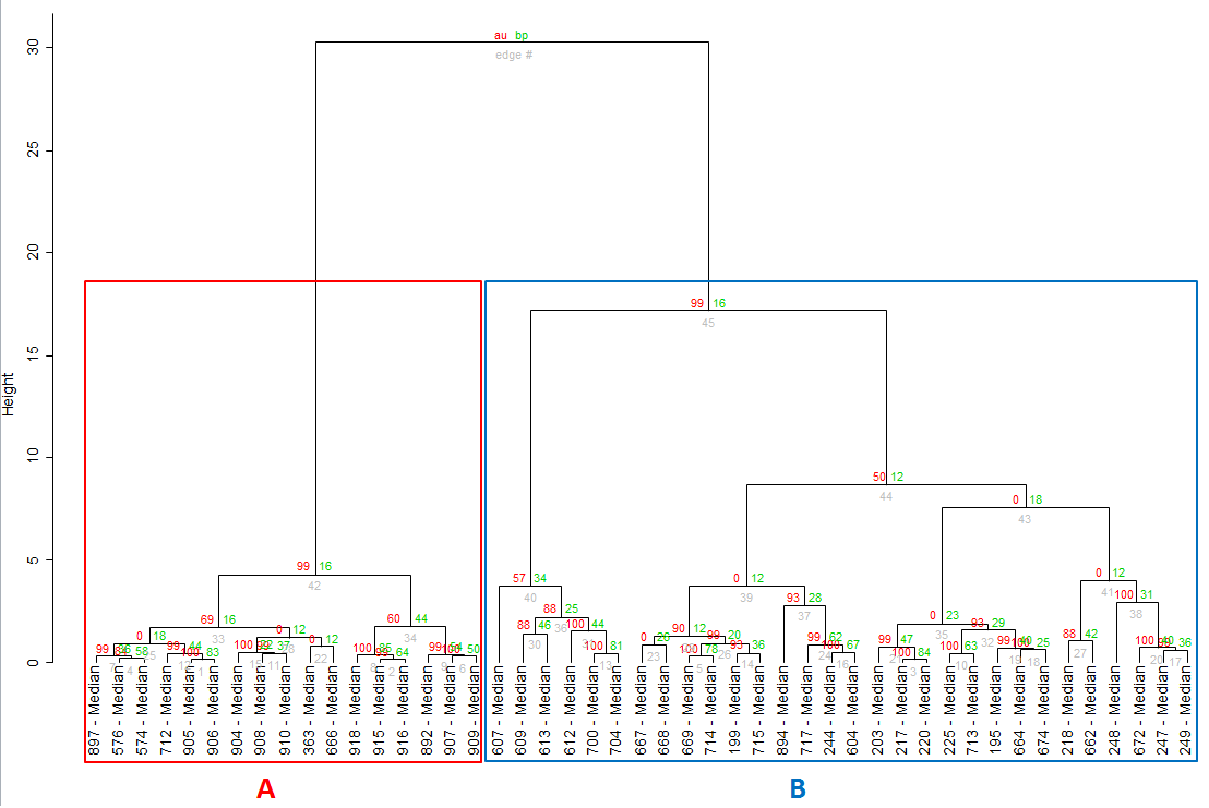
Fig.7: Cluster analysis of the median ecodistrict nutrients. Two main groups (illustrated by boxes) were identified by a 40% cutlevel and supported by a Approximately Unbiased P-value of 75% or higher.
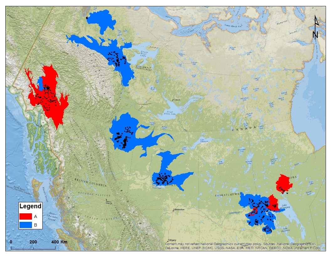
Fig.8: Ecodistrict grouping identified by the nutrient cluster analysis.
Gibbs Model
An assessment on the variability of chemistry composition was made by use of the Gibbs global model. The dominant processes influencing chemistry are explained by the interaction of climate and geology. This model identifies the dominant processes controlling the water chemistry and splits these into three major mechanisms: precipitation dominance, rock dominance and evaporation dominance. Samples are organized into one of these three mechanisms, based on the ion composition, more precisely the ratio of Na/(Na+Ca) in relation to the total dissolved solids (TDS) (Gibbs, 1970).
Following the cluster analyses, Gibbs models were calculated for each of the cluster identified in the geochemistry cluster analysis (Fig.5) to assess whether the differences in chemistry signatures coincided with differences in the mechanisms controlling the chemistry. Using the clusters identified by geochemistry, four sets of Gibbs models were calculated (Fig.9).
The Gibbs models indicate that clusters A and B are dominated by the mechanism of dissolution, due to their high TDS concentrations and ion ratios. This supports my assumption that the high geochemistry signatures identified near the Boreal Shield interface was due to continental groundwater flow, originating from the Boundary Range. This groundwater has accumulated excessive concentrations of ions by when reaching the Boreal Shield, but needs to surface at this interface, as the impervious bedrock of the Shield does not allow the groundwater to flow into the Shield. As for the ponds in the Boreal Cordillera showing high chemistry signatures, the cause here not continental groundwater, but rather their location atop highly weatherable dolomite bedrock. Groundwater flowing through this deposit accumulates high amounts of ions, releasing these concentrations when surfacing in the ponds.
The cluster analysis on geochemistry also gathered almost all of the remaining ponds situated in the Boreal and Taiga Plains into a single cluster (cluster C), showing a relative intermediate chemistry signature, but with a wide range of variability. The Gibbs model of this data cluster determined that the signature of this region was typically that of rock and soil dominance (lower TDS concentrations and low (less than 0.3) ion ratios, but with a wide range of variability). Again, this outcome was expected as almost all of these ponds are situated atop thick layers of overburden, dominating the landscape control on pond hydrochemistry, typical for the glaciated plains of Western Canada.
Lastly, cluster D shows the signature of systems dominated by precipitation, caused by their low TDS concentrations (less than 100 mg/L). The dominance of precipitation in these systems was due to the fact that all these ponds are located on landscapes reducing the hydraulic conductivity of the system. In the case of the northernmost ponds, all of them were located high levels of permafrost, effectively limiting the water sources for SWWs to local groundwater flow and precipitation. Similarly, the ponds located in the Boreal Cordillera exhibiting these low geochemistry signatures were all located directly on intrusive bedrock, acting in a similar manner as permafrost, heavily limiting the hydraulic conductivity of the system.
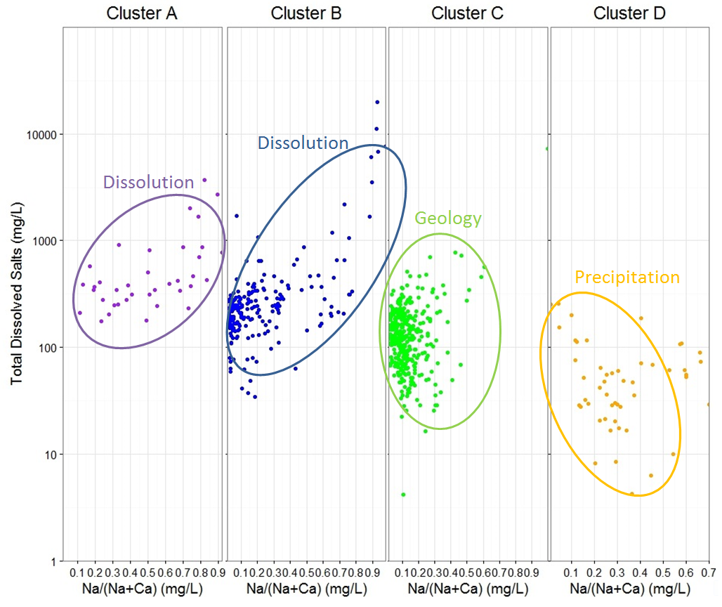
Fig.9: The Gibbs models performed on each of the clusters identified by the geochemistry cluster analysis (Fig.5).
Hydrochemistry - Landscape correlations
Data subsetting
 Fig.10: Subset of the sampled ecodistricts, chosen to reduce residual variation "noise" and captures strong variation in permafrost, bedrock geology, peatland area (%), and surficial geology.
The results of the cluster analyses and the Gibbs models illustrate that the variability in chemistry and the mechanisms controlling them are quite distinct between the different regions of the Western Boreal Forest. To create a properly supported MRT, free from the “noise” created by the residual variation of the different regions, the data needed to be subsetted to accurately capture the correlation between the variability in chemistry and the variability of the landscape.
Chemistry data subsetting started with the exclusion of all ponds located in Cluster A, identified by the nutrient cluster analysis, effectively removing the ponds sampled in the Boreal Cordillera and the Boreal Shield. The second exclusion was based on the results of the geochemistry cluster analysis and the Gibbs model. Clusters A and B were shown to be dominated by the process of heavy dissolution of the geology by groundwater movement, therefor showing high geochemistry signatures compared to the rest of the ponds sampled across Western Boreal Forest. All ponds located in cluster A and B were thus removed from the data subset as well. Finally, the ponds of cluster D, expressing precipitation as their dominant process and possessing low concentrations in geochemistry overall, were removed from our subset. This left a total of 391 ponds spread across the Taiga and Boreal Plains to be subjected to a MRT analysis.
Chemistry data subsetting started with the exclusion of all ponds located in Cluster A, identified by the nutrient cluster analysis, effectively removing the ponds sampled in the Boreal Cordillera and the Boreal Shield. The second exclusion was based on the results of the geochemistry cluster analysis and the Gibbs model. Clusters A and B were shown to be dominated by the process of heavy dissolution of the geology by groundwater movement, therefor showing high geochemistry signatures compared to the rest of the ponds sampled across Western Boreal Forest. All ponds located in cluster A and B were thus removed from the data subset as well. Finally, the ponds of cluster D, expressing precipitation as their dominant process and possessing low concentrations in geochemistry overall, were removed from our subset. This left a total of 391 ponds spread across the Taiga and Boreal Plains to be subjected to a MRT analysis.
Multivariate Regression Tee (MRT) - Geochemistry
A first MRT analysis was performed on the data subset to identify major correlations between the variability in geochemistry and the variability of the landscape. This tree showed two major splits in the dataset, providing three distinct groups (Fig.11). As with the cluster analyses, the data was normalized prior to the MRT analysis.
The first split in chemistry was correlated to permafrost variability. Ponds situated in a landscape dominated by sporadic (50-10% of the landscape) permafrost were split from ponds situated in either extensive (90-50%) or entirely absent permafrost.
Both branches encountered a further split, ponds located on extensive permafrost or absent of any permafrost showed a further split in each permafrost category respectively. Due to permafrost lowering the hydraulic conductivity of the landscape, effectively limiting the amount of regional groundwater received by ponds situated on extensive permafrost, these ponds showed lower geochemistry signatures compared to ponds absent of any permafrost (Table 2).
The branch containing ponds situated in sporadic permafrost also showed a secondary split, controlled by the percentage of peatland present in the area. As surface water inflow from peatlands is generally high in nutrients but low in ions, ponds located in areas with more than 75% of the area dominated by peatland showed a lower geochemistry signature compared to ponds situated in areas with less than 75% peatland.

Fig.12: The Multivariate Regression Tree of the subset of pond geochemistry. Each major split (or leaf) is numbered in brackets.
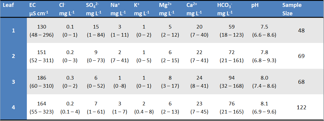
Table 2: Geochemistry signatures of each of the major leafs identified in the MRT (fig.11). Values represent the leaf median, while brackets present the 90% range.
Multivariate Regression Tee (MRT) - Nutrients
A second MRT analysis was performed on the data subset to identify major correlations between the variability in nutrients and the variability of the landscape. Again, the data was normalized prior to the MRT analysis. Unlike the previous analysis, not all ponds present in the data subset were included in this MRT, due to gaps in nutrient measurements. More specifically, no ponds located in sporadic permafrost are included in this analysis.
This tree showed two major splits as well (Fig.12). The first split in chemistry was correlated to the presence of permafrost. Ponds located in areas of extensive permafrost possessed much lower nutrient signatures overall compared to ponds situated in areas absent of permafrost (Table 3). This was due to permafrost lower the hydraulic conductivity of the landscape, limiting ponds to precipitation and local groundwater flow as inputs, both of which tend to be low in nutrients.
A second split was identified in ponds situated in areas absent of permafrost. This split in chemistry variability was correlated to the surficial geology, ponds situated on coarse deposits or fine hummocky terrain showed lower nutrient concentrations overall, compared to ponds located on fine plain landscapes. This was most likely due to variability encountered at a more local level, captured by the surficial geology. Peatlands develop best on a landscape dominated by fine plain deposits, as coarse deposits drain the area faster and fine hummocky deposits are to locally isolated to be effective.

Fig.12: The Multivariate Regression Tree of the subset of pond nutrients. Each major split (or leaf) is numbered in brackets.
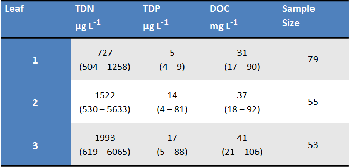
Table 3: Nutrient signatures of each of the major leafs identified in the MRT (fig.12). Values represent the leaf median, while brackets present the 90% range.
Discussion
As the results of the cluster analyses (Fig.5-8) show, there is a considerable dissimilarity in hydrochemistry across the Western Boreal Forest, both in geochemistry and nutrients. The cluster analyses and Gibbs model prove that the Western Boreal Forest cannot be considered homogeneous in baseline geochemistry variability and indeed distinct regions of unique geochemistry signatures exist. Pond and watershed management therefore cannot make the same management assumptions across all of these distinct regions and local research performed within these regions cannot be extrapolated to the other regions without taken into account the difference in baseline geochemistry of the specific region. Similarly, the cluster analysis performed on pond nutrients proved that the variability is not homogeneous across the Western Boreal Forest. While most of the ecodistricts sampled in the Taiga and Boreal showed insufficient dissimilarity to support further splits, further data exploration (not included) showed a strong difference in median nutrient signatures between the two unsupported clusters. It is assumed that this split was not supported as both clusters showed a considerable overlap in their range of variability. This leads me to hypothesise that ponds of the Western Boreal Forest show strong variability in nutrient signatures at the local sampling level and proper assessments of this variability require analyses at the local level.
The results of the MRTs were not as expected at the build-up of my conceptual model. My main assumptions were that variability in bedrock geology and depth to bedrock would control geochemistry variability, while the percentage peatland would control nutrient variability. Neither of these assumptions were supported by my results however. In both analyses, permafrost was determined to be the main controlling factor in chemistry variability, with the inclusion of percent peatland area and surficial geology at the second level branches for geochemistry and nutrients respectively. This outcome highlights the importance of the permafrost condition of the landscape a pond is located in and further supports that even research performed within the clusters identified earlier cannot be extrapolated to other areas without taking into account the effects of permafrost. However, both MRTs showed considerable high errors, indicating that 87% of the variability in geochemistry and 79% of nutrient variability are not explained by the landscape drivers at the regional level. All these outcomes support and validate the use of local research to drive pond management across Western Canada, a practice used heavily by many environmental management agencies.
The results of the MRTs were not as expected at the build-up of my conceptual model. My main assumptions were that variability in bedrock geology and depth to bedrock would control geochemistry variability, while the percentage peatland would control nutrient variability. Neither of these assumptions were supported by my results however. In both analyses, permafrost was determined to be the main controlling factor in chemistry variability, with the inclusion of percent peatland area and surficial geology at the second level branches for geochemistry and nutrients respectively. This outcome highlights the importance of the permafrost condition of the landscape a pond is located in and further supports that even research performed within the clusters identified earlier cannot be extrapolated to other areas without taking into account the effects of permafrost. However, both MRTs showed considerable high errors, indicating that 87% of the variability in geochemistry and 79% of nutrient variability are not explained by the landscape drivers at the regional level. All these outcomes support and validate the use of local research to drive pond management across Western Canada, a practice used heavily by many environmental management agencies.
