Data collection |
Between 2001 and 2003, individual water samples were gathered from a total of 882 ponds in the period of June-August. The collection samples was performed in cooperation with Ducks Unlimited Canada, and survey ponds were randomly sampled within ecodistricts, but general locations of sampling were chosen to incorporate all bedrock geologic types observed in the area. A one liter grab sample of water was collected from the middle of the open water area of each pond by helicopter. Water samples were packed in ice filled coolers and shipped to the University of Alberta Limnology lab for chemistry analysis. Data on the different landscape controls were gathered from a collection of sources (Table 1) in the format of data layers in ArcGIS. Following acquisition of these datasets, they were projected in ArcMap and linked to the specific coordinates of each individual pond.
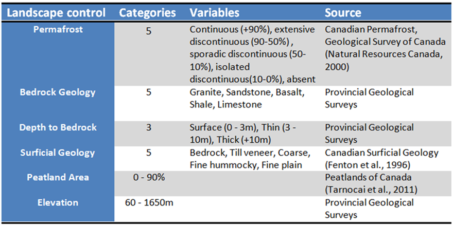
Table 1: Landscape control inventory
Analyses
Having created a proper dataset containing all the links between pond hydrochemistry and my different landscape controls, I started my analysis by assessing the general variability and overall range in hydrochemistry and landscape variables using principal component analyses (PCAs) and basic boxplots to assess the non-normality of the data. Next, I investigate the similarity between my observations in pond chemistry. By performing a cluster analysis with significance testing, I attempt to identify distinct regions of similar hydrochemistry across the Western Boreal Forest. By identifying clusters with similar signatures, I aim to gather ponds into meaningful subgroups, experiencing similar influences from their landscape. Following the cluster analyses, Gibbs models are used as a conceptual outline to identify the dominant processes controlling the water flowing into the ponds and assess whether distinct clusters are affected by different processes. Finally, a multivariate regression tree is performed
